
Historically the combined districts of Burnley, Pendle and Wets Craven have long
been something of an archaeological 'no-
The northern fringes of the area have rapidly expanded from a series of small riverside settlements into the cotton town conurbations of Burnley, Nelson and Colne; the rural subject of our study, however, survives as a relatively untouched swathe of marginal dairy and moorland sheep grazing land. No major developments (motorway, supermarket or housing) has brought teams of archaeologists onto these river valleys and uplands.
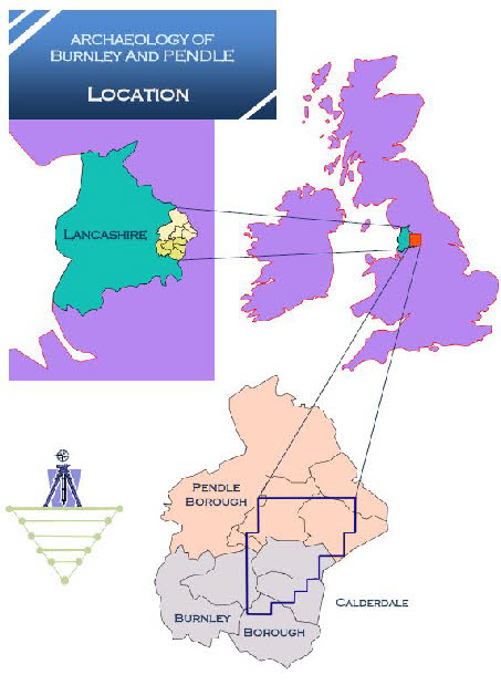
To address this situation, local landscape archaeologist and historian, John Clayton of Barrowford, decided to implement an archaeological survey over a wide strip of land stretching from the natural landscape boundaries formed by the Burnley moors in the south and the rolling drumlin hills around Long Preston to the north. The urban fringes of Burnley, Nelson, Colne and Earby were set as the eastern survey limit with the ridge of Boulsworth Hill separating the survey from neighbouring Calderdale.
The Burnley, Pendle and Wst Craven Archaeology Project began in January 2013 and
is an ongoing undertaking; the basic project remit is to obtain an overview of archaeological
landscape features within the eighty-
The LiDAR results are used along with other forms of aerial imagery and historical resources to record apparent archaeological features within the Survey area. The results are logged and mapped through the facility of GPS (Global Positioning) and GIS (Geographic Information Systems) and stored in GIS database form for future reference and accurate creation of landscape feature maps.
The intent of the Survey is to provide as much evidence for surviving prehistoric
landscape archaeology within the survey districts as possible (within the constraints
of a largely non-
The survey results suggest a far greater occupation of the survey area within the prehistoric and Medieval periods than has been previously recognised. A number of Neolithic and Bronze Age burial sites are recognised throughout the area today but the aerial evidence suggests that many more exist. Ritual monuments in the form of stone circles once existed at Blacko, Fence, Nelson and Burnley and the Survey has been instrumental in locating the probable site of these features. At least six lost villages, some prehistoric and some possibly Medieval, appear within the LiDAR data, along with ten previously unknown hillfort features and ancient burials.
Our area of the South Pennines boasts the richest Mesolithic landscape within Britain. The first settlers lived on the high moorlands of Boulsworth and Calderdale while their successors steadily moved into the lower land between the rivers and the hills. This means that we are able to suggest a pattern of the movement of people across our region, and their settlement within it, during the period extending from the last Ice Age to the Iron Age. Gradually we see the emergence of a familiar system of fields being created and it is fair to say that some of the fields in existence today were created in the Bronze and Iron Age periods.

HOME


The Pendle District
Community Archaeology Group
Rewriting Local History

THE BURNLEY, PENDLE AND WEST CRAVEN
ARCHAEOLOGY SURVEY
THE BPC ARCHAEOLOGY SURVEY BEGAN IN JANUARY 2013. THE SURVEY INITIALLY COVERED 63 SQUARE KILOMETRES OF THE BURNLEY AND PENDLE DISTRICTS OF EAST LANCASHIRE. HOWEVER, FROM THE SPRING OF 2015 THE SURVEY HAS BEEN EXTENDED INTO THE FORMER DISTRICT OF WEST CRAVEN AND HAS EXPANDED TO OVER 83 SQUARE KILOMETRES.
Aerial laser technology (lidar) has been utilised to cover the whole of the subject area and this makes it one of the most ambitious projects of its type ever to have been undertaken within the UK. Consequently (as at September 2015) an amazing volume of new archaeological features are becoming available to the local archaeological record.
2015
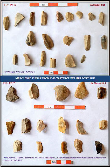
Microlith flint tools from the Castercliffe hillfort site, Colne.
View a selection of finds from the Project:
PLEASE NOTE THAT ALL MATERIAL ON THIS SITE
IS SUBJECT TO STANDARD LEGAL TERMS OF COPYRIGHT
PUBLISHED SURVEY RESULTS TO 2014


SURVEY CONTACT

PROJECT ARTEFACTS AND TOOLS . . . . .


PROJECT SITES AND LOCATION DETAILS